The Boston Marathon is one of the most prestigious running events in the world, with a rich history dating back over a century.
The Boston Marathon Route is a challenging course that takes runners through historic towns and landmarks and offers breathtaking views along the way.
Whether you are a seasoned marathon runner or a beginner looking to take on a new challenge, the Boston Marathon Route is a must-do for any serious runner.
In this article, we will provide a detailed overview of the Boston Marathon Route, including:
- The Marathon Route Profile,
- Mile-by-mile breakdown of the course, and
- Key Landmarks along the Boston Marathon Route to Watch Out for.
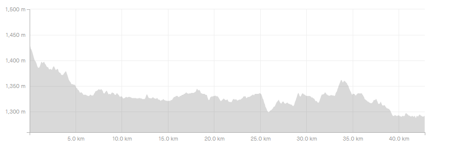
Boston Marathon Route Profile
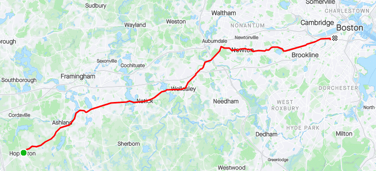
The Boston Marathon Route is a 26.2-mile( 42.2-km) course that starts in Hopkinton, Massachusetts, and finishes in Boston. The course has a net elevation loss of 459 feet(139.9 meters), with the highest point at the start and the lowest point at the finish.
The first half of the course primarily consists of gently rolling hills, with a notable climb occurring before Wesley.
The second half of the course is known for its challenging hills, particularly the famous Newton Hills spanning roughly 25-30km. The final stretch includes the feared Heartbreak Hill. However, the last few kilometers are mostly gentle downhill, leading runners to the finish line.
The Boston Marathon Route is considered a difficult course, with its rolling hills and challenging terrain. The course records for men and women are 2:03:02 and 2:19:59, respectively.
To help you prepare for this legendary race, we have put together a mile-to-mile breakdown of the Boston Marathon route, highlighting key landmarks, elevation changes, and other important details along the way.
Boston Marathon Accommodation: The BEST Hotels For Runners
Boston Marathon Mile-to-mile Breakdown
Start Line to Mile 1
When the starting gun fires, the adrenaline rush can make you eager to take off at a fast pace.
However, it’s important to resist this urge and start slower than you feel necessary.
The Boston Marathon course begins with a pleasant downhill stretch, but around 800 meters in, there’s a slight uphill that catches many runners off guard.
Despite this, the first 400 meters of the course are exhilarating and you’ll likely feel like screaming as you descend.
Mile 1 to Mile 2
As the second mile begins towards Ashland, the frenzy of the first mile subsides.
The downhill pitch evens out, crowds thin, and runners spread out. Rolling hills early in the race may surprise some who expect them to start in Newton.
Hopkinton is crossed off the list as runners head toward Ashland.
Mile 2 to Mile 3
Ashland was the starting line for the Boston Marathon from 1897 to 1923. It’s a lively place with cheering crowds and some rolling hills, but a net descent.
Keep an eye out for TJ’s Food and Spirits for some loud music and support.
Mile 3 to Mile 4
The third mile of the Boston Marathon features two recognizable Massachusetts logos, the Dunkin Donuts and the “T” for the Ashland Commuter Rail station.
As the course progresses, the scenery transitions from rural to commercial. Along the way, runners will encounter the clock tower at the intersection of Union and Chestnut Streets, a notable landmark of the course.
In times gone by, this spot served as a significant checkpoint for runners to assess whether they were on track for their target times or not.
Mile 4 to Mile 5
This mile marks the transition from Ashland to Framingham and is the first mile on the course that has an elevation gain of 25 feet.
Beyond the Shell Station on Route 135, a half-mile climb leads to a building supply store and a large storage facility.
The 4.8-mile mark signals the entrance into Framingham, the third of eight towns on the course.
Mile 5 to Mile 6
Throughout this mile, there are three minor rolling hills with a net descent.
The landscape transitions to an industrial atmosphere, and the field of runners disperses considerably, allowing for a comfortable pace.
The 6-mile marker is located at Bridge Street.
Mile 6 to Mile 7
At the start of this mile, you’ll descend downhill.
The Framingham Train Station is a notable landmark at the 6.2-mile mark. In 1907, a train switching tracks caused an inconvenience for all but the lead pack of runners.
Crossing tracks is required, so be cautious.
Mile 7 to Mile 8
Around mile 7.3, you’ll cross the border into Natick.
A short uphill climb follows, passing by a Wendy’s on your left, and soon after, you’ll come across the West Natick train station and the 8-mile marker.
Mile 8 to Mile 9
This mile starts with a slight climb past some office buildings, a very large Planet Fitness gym, and a car dealership.
There’s another incline past Speen Street, but we’re talking minor hills here. Overall it’s a pretty flat mile.
Mile 9 to Mile 10
This mile starts quietly. You’ve got train tracks on your left and Lake Cochichuate on your right, so not a whole lot of space for spectators.
It’s flat.
You’ll hit the 15k mark as you come to the end of the lake, and you’ll enter a historic district, which is a nice switch from the commercial and industrial landscapes of previous miles.
Mile 10 to Mile 11
At approximately the 8.8-mile mark, you’ll traverse Natick Center, passing by the fire department and municipal buildings, as well as the First Congregational Church with its towering steeple situated on the left-hand side of the road.
Expect significant crowds in this area.
Mile 11 to Mile 12
This mile starts uphill, and after the first quarter-mile, rolls downhill until almost the 12-mile mark.
In the last half, it’s pretty quiet, with thick woods on your right side
Mile 12 to Mile 13
As you approach the main gate of Wellesley College, the noise level will suddenly increase.
Once you’re there, get ready to experience the famous Wellesley College screaming tunnel.
This women-only college in the USA is renowned for its enthusiastic and spirited Wellesley GURLS who create an exhilarating atmosphere along the course.
You’ll pass the 20k mark with a little drop, and then you’ll climb to Wellesley Center.
Mile 13 to Mile 14
This mile through downtown Wellesley offers lively crowds and pleasant surroundings.
It’s a great morale booster as you reach the halfway point of the race.
From here on in, you can just keep telling yourself that you’re closer to Boston than to Hopkinton.
But also keep in mind the old adage about a marathon having two halves – the first 20 miles and the last 6.2. Definitely true of this course.
So enjoy this fast, mostly flat mile. You’re closing in on the rough stuff.
Mile 14 to Mile 15
At 14 miles you’ll see tennis courts and athletic fields on your right. It’s flat and pretty. You’ll come to another quaint commercial district along the way.
Mile 15 to Mile 16
Mile 15 starts with a little climb that tops out quickly. You’re in a lovely residential area; you’ll see some nice stone buildings. It’s flat for about a quarter of a mile. And then… two words, people: IT’S ON!!
Halfway through this mile the road plunges, barreling more than a hundred feet down into Newton Lower Falls, where the mile ends.
Many insist this is where the real race begins.
Racing or not, it’s where the storied course will begin to test you. You’re going to be climbing and dropping for about the next nine miles. None of these hills, up or down, is a killer on its own.
It’s the cumulative effect and the fact that when the uphills start, your legs already have 16 miles on them.
If you’re whipped at 16, you’ve got some rough miles ahead.
Mile 16 to Mile 17
After descending for half a mile into Newton Lower Falls, the road briefly flattens before the “Entering Newton” sign and Lower Falls Wine Company appear.
The start of a challenging uphill climb follows, stretching for over half a mile.
Although not incredibly steep, this hill is notorious for its length, making it a formidable obstacle.
First-time runners may be caught off guard, as the Newton Hills are often associated with the series that begins at the firehouse one mile ahead.
Along the way, you’ll pass Newton Wellesley Hospital, and the road will level off as you approach Woodland Golf Club and the 17-mile marker.
Mile 17 to Mile 18
Mile 17 starts out nice and flat.
You’ll pass the Woodland Green Line T station on the right. It’s a nice residential stretch.
At 17.3 miles, you’ll make one of the two famous turns on this course, known as “the turn by the firehouse.”
The right turn onto Commonwealth Avenue, at the firehouse on your right, brings huge crowds, lots of noise and encouragement, and a lot of energy.
Mile 18 to Mile 19
After the 18-mile mark, the road tilts up again, but in the scheme of things, this is a speed bump.
This mile is mostly flat or gently downhill. You’ll cross Chestnut Street about three-tenths of a mile in.
You should be able to cruise past the 30k mark and ride a short drop to the 19-mile mark.
Mile 19 to Mile 20
At mile 19, you’ll come across Newton City Hall. On the far left, across Walnut Street, there’s a remarkable homage to Johnny Kelley, the legendary Boston Marathon winner and finisher of 61 races.
The “Forever Young” sculptures showcase a youthful and older Kelley running together.
As you hit the .9 mark, you’ll cross Centre Street, where you’ll spot Heartbreak Hill Running Company on the corner.
The current stretch may make you feel as if you’re partaking in a mountainous sport.
Mile 20 to Mile 21
As you cross the 20-mile mark, you can see the base of Heartbreak Hill where the road winds ahead.
Heartbreak is a steep half-mile uphill. It will likely not be the longest or the steepest hill you’ll ever run but, again, at this point, you’re probably not running on fresh legs.
Mile 21 to Mile 22
As you approach the end of Mile 21, you’ll step into Boston College’s domain.
The road takes a steep dive here for half a mile, which might seem like a refreshing change from the uphill challenges of Newton.
You should prepare yourself for the deafening roar of the BC Eagles supporters.
Following a short ascent of about a tenth of a mile, you’ll descend once again, passing by a cemetery.
Mile 22 to Mile 23
Be cautious of the Green Line trolley tracks as you enter Cleveland Circle. You’ll need to cross multiple sets of tracks, so pay attention to your footing.
The mile ends with a gentle climb that extends for a quarter-mile, and you’ll then enter Brookline.
Mile 23 to Mile 24
At mile 23, descend along Beacon Street through Brookline’s Washington Square neighborhood past restaurants and shops. The road briefly inclines, but it’s mostly downhill with one noticeable uphill.
As you near Coolidge Corner, you’ll catch a quick glimpse of Boston’s Citgo sign about 1.5 miles away.
Mile 24 to Mile 25
At the intersection of Beacon and Charles Streets in Brookline, just past Coolidge Corner, you’ll hit the 24-mile mark.
The mile ends with a slight undulation and a long downhill, passing shops, restaurants, and condo buildings.
Even the flat section feels heavy after the downhill.
Mile 25 to Mile 26
The final mile starts with a slight descent and offers a view of Fenway Park on your right.
After leaving the square, you’ll go under some overpasses and then pass through “the turn on Hereford,” a slightly uphill right turn known for its enthusiastic crowds.
Next, you’ll pass Newbury Street and turn left onto Boylston Street, with the finish line in sight ahead.
Mile 26 to Mile 26.2
The 26-mile mark is inconspicuous as you near the finish line.
The final stretch is flat and takes you past Prudential Center, Gloucester, Fairfield, and Exeter Streets.
The finish line is before Dartmouth Street, next to the Boston Public Library and Copley Square.

Boston Marathon Route Run-Through
As a runner, you can benefit greatly from the Boston Marathon Run-Through, as it provides an essential resource for understanding the course and planning your strategy.
Pay close attention to the elevation changes, hills, and descents along the Boston Marathon Route, as these factors can greatly impact your performance.
It is important to be aware of any sharp turns or narrow sections of the course that may require you to adjust your running form or pace accordingly.
Here are some of the most well-known sharp turns to look out for:
Sharp Turns To Be Aware of Along the Boston Marathon Route
Sharp turns and narrow sections can be found at various points throughout the Boston Marathon Route.
For example, one of the most notable sharp turns occurs near the beginning of the race, where runners turn from Main Street onto East Main Street in Hopkinton.
This turn can be challenging for runners who may be jostling for position in a crowded field, and it can also be difficult for runners to maintain their pace on the subsequent uphill section of the course.
Another notable narrow section of the course is the stretch of Commonwealth Avenue known as “Heartbreak Hill,” which begins around mile 20 of the race.
This section of the course features a series of challenging hills and sharp turns that can be particularly difficult for runners who are already fatigued from the long distance of the race.
Other sharp turns and narrow sections can be found throughout the course, including around Boston College and near the finish line on Boylston Street.
It is important for runners to familiarize themselves with these sections of the course and to adjust their running form and pace accordingly in order to stay safe and perform their best.
Additionally, knowing the location of aid stations and water stops along the course can help you plan your fueling strategy and ensure that you stay hydrated throughout the race.
Hydration Stops Along the Boston Marathon Route
Staying hydrated during the Boston Marathon is essential to prevent dehydration and maintain performance.
Hydration stations are located along the route, offering water and sports drinks.
Starting at Mile Two, runners can find hydration stations serving Poland Spring Water and Lemon Lime Gatorade Endurance Formula along the course.
To mitigate plastic waste TCS has put major sustainability efforts in place which we discuss in this article.
Three Maurten Hydrogel stations will be located on the course:
- mile 11.8 on the Wellesley town line;
- mile 17 in Newton; and at,
- mile 21.5 just after Boston College.
Maurten’s Gel 100 (non-caffeinated) and Gel 100 CAF 100 (caffeinated) will be available.
Pro Tip: The BEST Marathon Hydration Strategy According To Experts
Key Landmarks Along The Boston Marathon Route
The Boston Marathon Route Map includes key landmarks that you should be aware of.
You will encounter the infamous Heartbreak Hill, a challenging incline that appears in the later stages of the race and tests the endurance of even the most experienced runners.
Keep an eye out for other notable landmarks on the course, such as the Wellesley College scream tunnel, which can give you an energetic boost, and the iconic Citgo sign near the finish line, which serves as a beacon of hope for tired and exhausted runners.
These landmarks can serve as motivation and inspiration for you during the race, and can also help you track your progress along the course.
Boston Marathon Elevation Chart
By utilizing the Boston Marathon elevation charts, you can create an effective race strategy that takes into account the specific paces you should maintain based on the elevation changes along the route. This will help you achieve your desired Boston Marathon time goal.
Boston Marathon Google Maps Link
When preparing for the race, make use of the map to zoom in and familiarise yourself with the roads you will be running on during the race.
Boston Marathon GPX File
Having a GPX file of the Boston Marathon can prove to be an invaluable asset when it comes to planning and preparing for the race.
This digital file can be uploaded to various platforms, such as Google Maps or a fitness watch, enabling runners to interact with and utilize the map to its fullest potential.
With the GPX file, runners can carefully examine the course and strategize their race-day approach.
By knowing the terrain and elevation changes beforehand, runners can prepare themselves physically and mentally for any challenges they may face along the course.
The file can also provide a sense of security and confidence, as runners can stay on track and monitor their progress throughout the race.
If you’re not participating in the race but would like to support your friends or family by cheering them on from the sidelines, we’ve compiled a guide to the Top Spectator Spots along the Boston Marathon Route.


Comments are closed.